Geography and Environment
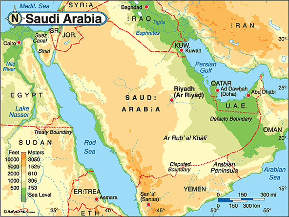
This physical map of Saudi Arabia shows how a majority of the country is covered in a desert. You can also see the elevation of different parts of Saudi Arabia. There is an area of the country that is sea level to the southeast but to the southwest, we can see that the elevation is actually quite high. (http://www.maps.com/ref_map.aspx?pid=12334)

This physical map displays the average rainfall in Saudi Arabia. Dryness is the prevailing climatic characteristic of Saudi Arabia except in the Asir region (centered on Abha), which receives annual rainfall > 300 mm due to its unique geographical configuration and the local mountains. Rainfall in most of Saudi Arabia is < 200 mm and highly irregular. (http://www.nar.ucar.edu/2008/RAL/images/1.2_aerosols_a_08_lg.jpg)

This population density map of Saudi Arabia shows a human characteristic on Saudi Arabia. The darker the color, the more highly populated the area is. The most highly populated area of Saudi Arabia is around Mecca, a prominent city in Saudi Arabia. The map also shows where province capitals and the country capital is. (http://www.bestcountryreports.com/Population_Map_Saudi%20Arabia.php)
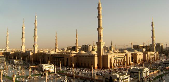
This picture shows an Islam mosque in Saudi Arabia. The mosque is a definite human characteristic because humans built this Islam worshiping place. (http://www.internations.org/saudi-arabia-expats/guide/living-in-saudi-arabia-15364)

The rolling desert plains of Saudi Arabia are prominent physical features in the country. Saudi Arabia consists mainly of deserts. (http://www.teachaway.com/teaching-english-saudi-arabia)

This image shows Mecca, the most prominant city in Saudi Arabia. Mecca is the center of Islam. This is a picture of the highly human characteristic, the The Ka’ba (The Great Mosque). Mecca is considered the most holy place in the Islam religion. (http://sacredsites.com/middle_east/saudi_arabia/mecca.html)

This physical landform is a prominent escarpment of the Ṭuwayq Mountains, just south of Riyadh, Saudi Arabia. (http://www.britannica.com/EBchecked/media/91487/Prominent-escarpment-of-the-Tuwayq-Mountains-just-south-of-Riyadh)

This image shows both physical and human characteristics. The mountains and desert around the roads display the dry environment of Saudi Arabia. The roads portray the human aspect of the picture. The humans were able to build their roads through the harsh landscape. (http://www.distancesbetween.com/blog/wp-content/uploads/2011/09/riyadh-makkah-saudi-arabia.jpg)
Sources:
Saudi Arabia Physical Map by Maps.com from Maps.com -- World�s Largest Map Store. (n.d.). Retrieved from http://www.maps.com/ref_map.aspx?pid=12334
Retrieved from http://www.nar.ucar.edu/2008/RAL/images/1.2_aerosols_a_08_lg.jpg
Population Density Map of Saudi Arabia by BestCountryReports.com. (n.d.). Retrieved from http://www.bestcountryreports.com/Population_Map_Saudi%20Arabia.php
Living in Saudi Arabia | InterNations.org. (n.d.). Retrieved from http://www.internations.org/saudi-arabia-expats/guide/living-in-saudi-arabia-15364
Teach in Saudi Arabia - Teach English in Saudi Arabia - Teaching in Saudi Arabia | Teach Away Inc. (n.d.). Retrieved from http://www.teachaway.com/teaching-english-saudi-arabia
Mecca, Saudi Arabia. (n.d.). Retrieved from http://sacredsites.com/middle_east/saudi_arabia/mecca.html
Ṭuwayq Mountains -- Encyclopedia Britannica. (n.d.). Retrieved from http://www.britannica.com/EBchecked/media/91487/Prominent-escarpment-of-the-Tuwayq-Mountains-just-south-of-Riyadh
Retrieved from http://www.distancesbetween.com/blog/wp-content/uploads/2011/09/riyadh-makkah-saudi-arabia.jpg
